Trail Touring skiing Le Monêtier-les-Bains - pointe de Reou d arsine - Photo
 tchoua
tchoua

User

© OpenStreetMap contributors
Length
Length
34 km
Max alt
Max alt
2806 m
Uphill gradient
Uphill gradient
1365 m
Km-Effort
Km-Effort  
54 km
Min alt
Min alt
1209 m
Downhill gradient
Downhill gradient
1663 m
Boucle
Boucle
No
Creation date :
2023-02-17 06:17:43.075
Updated on :
2023-03-24 08:28:27.18

(0 Reviews)

Touring skiing
Touring skiing
4h15
Difficulty : Difficult

Scan this QR Code to open this trail in the SityTrail application

FREE GPS app for hiking

Logo SityTrail SityTrail

IGN / Geographical institutes

Download SityTrail from the App Store Download SityTrail from Google Play

Logo SityTrail SityTrail World

The world is yours!

Download SityTrail from the App Store Download SityTrail from Google Play Download SityTrail on Huawei AppGallery

About

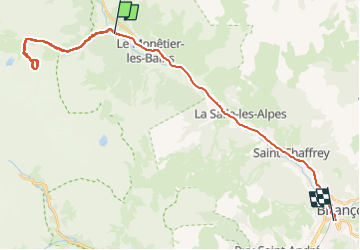
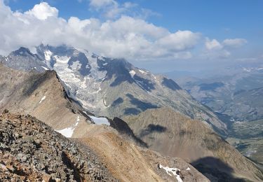
Trail Touring skiing of 34 km to be discovered at Provence-Alpes-Côte d'Azur, Hautes-Alpes, Le Monêtier-les-Bains. This trail is proposed by tchoua.

Description

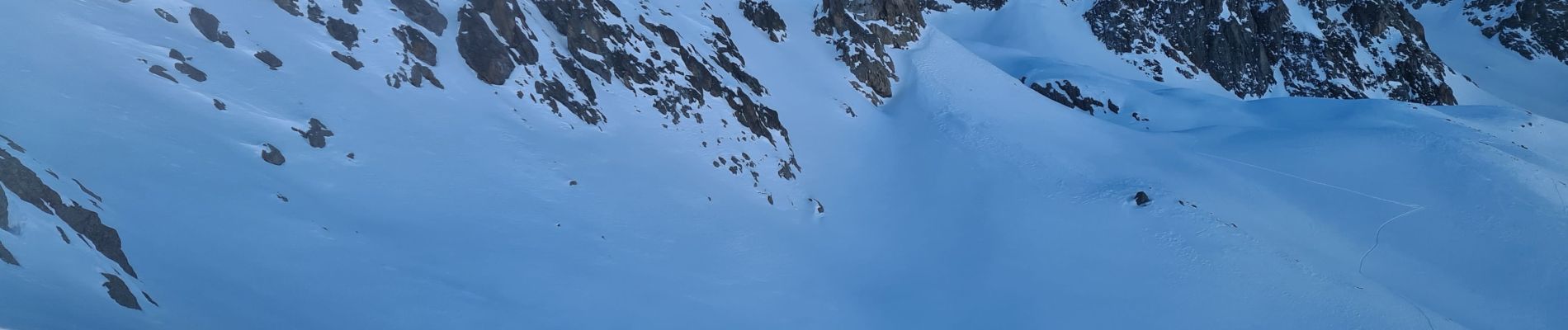
Jolie randonnée à faire à ski ou à pied l été sans aller sur les glaciers on a une belle vue, l itinéraire que j ai fait à ski fait prendre une moraine très raide au début juste après le col d arsine ce n est pas obligatoire d autant que cela peut s avérer dangereux si les pentes sont chargées il vaut mieux continuer par la droite comme l on fait pour accéder au pied du glacier du reou d arsine ( voir mon itinéraire sur glacier du réou d arsine)

Elevation profile

Photos

Positioning

Country:
France
Region :
Provence-Alpes-Côte d'Azur
Department/Province :
Hautes-Alpes
Municipality :
Le Monêtier-les-Bains
Location:
Unknown
Start:(UTM)
301748 ; 4984325 (32T) N.

Trails nearby

Trail Walking Le Monêtier-les-Bains - Le Grand Lac - Photo
Walking
tracegps

Walking

Difficult
(2)
Le Monêtier-les-Bains, Provence-Alpes-Côte d'Azur, Hautes-Alpes, France
5.2 km | 12.8 km-effort
5h 0min
No
Trail Walking Le Monêtier-les-Bains - pic est de Combeynot - Photo
Walking
GUIDE
amiral13

Walking

Very difficult
Le Monêtier-les-Bains, Provence-Alpes-Côte d'Azur, Hautes-Alpes, France
13.3 km | 33 km-effort
6h 24min
Yes
Trail Walking Le Monêtier-les-Bains - l'aiguillette du Lauzet par le grand lac - Photo
Walking
GUIDE
amiral13

Walking

Difficult
Le Monêtier-les-Bains, Provence-Alpes-Côte d'Azur, Hautes-Alpes, France
13.8 km | 29 km-effort
8h 39min
Yes
Trail Walking Le Monêtier-les-Bains - Chalet de l'Alpe - Grand lac - Croix 15/08/18 - Photo
Walking
GUIDE
R@ph

Walking

Medium
Le Monêtier-les-Bains, Provence-Alpes-Côte d'Azur, Hautes-Alpes, France
11.7 km | 22 km-effort
4h 23min
Yes
Trail Via ferrata Le Monêtier-les-Bains - Via ferrata Aiguillette du Lauzet 30/06/18 - Photo
Via ferrata
GUIDE
R@ph

Via ferrata

Medium
Le Monêtier-les-Bains, Provence-Alpes-Côte d'Azur, Hautes-Alpes, France
9.5 km | 21 km-effort
2h 30min
Yes
Trail Walking Le Monêtier-les-Bains - Haut tour des Cerces - Photo
Walking
druilhe

Walking

Very difficult
(1)
Le Monêtier-les-Bains, Provence-Alpes-Côte d'Azur, Hautes-Alpes, France
42 km | 77 km-effort
15h 27min
Yes
Trail Walking Le Monêtier-les-Bains - Le grand lac - Photo
Walking
GUIDE
amiral13

Walking

Medium
Le Monêtier-les-Bains, Provence-Alpes-Côte d'Azur, Hautes-Alpes, France
10.7 km | 20 km-effort
6h 15min
Yes
Trail Walking Le Monêtier-les-Bains - Lac du Glacier d'Arsine - Photo
Walking
patsure

Walking

Difficult
(1)
Le Monêtier-les-Bains, Provence-Alpes-Côte d'Azur, Hautes-Alpes, France
16.3 km | 29 km-effort
Unknown
Yes
Trail Walking Le Monêtier-les-Bains - alpe du lauzet - Photo
Walking
GALIBER

Walking

Easy
Le Monêtier-les-Bains, Provence-Alpes-Côte d'Azur, Hautes-Alpes, France
3.7 km | 6 km-effort
3h 12min
No


Close
My subscriptions